
 urbexology.com
No paid content found
 Multilingual
Categories: Social & Community
Most complete free urbex map on the internet. Over 1,000,000 locations of spots of lost places listed by the community. Abandoned world. Help you find abandoned or haunted places near you. Also, a unique set of mapping tools to help you discover new potentially abandoned places for your urban explorations and urban session.
 Visit website
 Updated: 2026-09-30 21:57
Language: English (default)
Updated: 2026-09-30 21:57
Language: English (default)
 Access: Normal
 Profile views 6
 Outbound visits 0
Related questions
More questions →How to Find Urbex Locations and What to Check Before You Go
An urbex location is any abandoned or disused place you can explore—factories, hospitals, military buildings, prisons, residential properties, or underground sites. The fastest way to find candidates near you is a community urbex map like Urbexology, which lists over 1,000,000 spots with filters for building type, area, and zone. But a listing is only a lead, not a guarantee: the site itself states there is no proof the places are actually abandoned, that positions are approximate and "ALMOST ALL OBSOLETE," and that you must do all necessary research before going. Treat every pin as a starting point for verification, not a destination.
What Counts as an Urbex Location
Community maps typically group spots into recognizable categories:
- Industrial sites — factories, plants, warehouses
- Institutional buildings — abandoned hospitals, prisons, schools
- Military structures — bunkers, barracks, depots
- Residential properties — houses, apartment blocks
- Underground sites — tunnels, cellars, subterranean facilities
- Haunted or decay-focused spots — locations flagged for atmosphere or local legend
Urbexology's own description highlights underground sites (hospitals, industrial plants, military buildings, residential properties, prisons) as core categories, and its filters let you narrow by buildings only in forests, buildings only in industrial zones, or minimum floor area. Those filters matter because they change what kind of trip you're planning—a forest cabin and an industrial plant carry very different access and risk profiles.
How Community Maps Collect and Show Locations
Most community urbex maps work the same way:
- Contributors add spots by dropping a pin, optionally attaching up to 3 images (Urbexology caps uploads at 25 MB each).
- Coordinates are stored and displayed on map, satellite, and terrain views.
- Other users filter, search, and set alert zones to be notified when new spots appear nearby.
- Errors get reported through a location report button for private, occupied, hazardous, or inaccurate listings.
One important limitation from the source: some positions are approximate coordinates extracted from OpenStreetMap and described as almost all obsolete. That means a pin may point to a general area rather than a precise entrance—plan to scout from a distance before committing.
What to Verify Before You Go
Because listings aren't verified as abandoned, your own research does the real work. Check these before any trip:
| Check | What to look for |
|---|---|
| Ownership status | Private property, active ownership, or occupied use |
| Access legality | Local laws, trespass rules, posted restrictions |
| Site condition | Structural decay, hazardous materials, unstable floors |
| Current use | Whether the site has been reused, demolished, or secured |
| Recent reports | Community notes on access, hazards, or changes |
Useful verification methods include satellite and street-level imagery, local historical records, news archives, and asking in community channels. The site's own framing—"Research architecture and local history"—reflects this: the map is a research tool, not a permission slip.
Legal, Safety, and Age Conditions
The source is explicit about boundaries:
- Respect local laws and private property above all.
- Never enter private property.
- Do not enter unsafe places.
- The service is for adults aged 21 and over.
- You are solely responsible for your actions.
Map records "do not establish public access, permission to enter, or safe conditions." Even a correctly pinned abandoned building can be privately owned, actively monitored, or structurally dangerous. If a site is occupied, hazardous, or private, report it rather than visiting.
Reporting and Contributing Responsibly
If you find an inaccurate or dangerous listing, use the location report button and select a reason (private, occupied, hazardous, inaccurate). To add a new spot, contributors must be certain the place is absolutely abandoned and that it poses no risk to anyone—a high bar that reflects how easily bad pins mislead others. Note that some spots are visible to pro members only, and the iOS app does not provide directions, access reports, community discussions, or visit tracking, so plan research on the web version.
Practical Trip-Planning Takeaways
- Start with filters (forest vs. industrial, minimum floor area) to match the kind of site you want.
- Set an alert zone if you want notifications about new spots in your area.
- Cross-check every pin against satellite imagery, historical records, and local knowledge.
- Assume coordinates are approximate and may be outdated.
- Verify ownership, access, and safety before leaving—and skip anything that fails.
- Report bad listings so the next person isn't misled.
The map gets you to a candidate. The research, the law, and your own judgment decide whether it's a location you can actually visit.
What Is an Urbex Map and How Do You Use One to Find Abandoned Places?
An urbex map is a community-sourced map of abandoned or lost places, typically showing coordinates, photos, and filters so you can find spots near you. On urbexology.com, the map is built from community submissions and is described as having over 1,000,000 locations. The critical condition: listings are not verified as abandoned, accessible, or safe, so you must do your own research before visiting. The service is for adults aged 21 and over, and the site states you are solely responsible for your actions.
How a community urbex map works
The map is collaborative. Users add spots, and the site explicitly notes there is no proof that the places are actually abandoned. Some positions are approximate and extracted from OSM, and the site warns that these are "ALMOST ALL OBSOLETE." That means a pin on the map is a starting point for research, not a confirmed destination.
The site also states that map records may be inaccurate and do not establish public access, permission to enter, or safe conditions.
What you can filter and search
According to the site's own interface text, the map supports:
- Building type filters — for example, buildings only in forests, or buildings only in industrial zones
- Building area filter — set a minimum floor area for the pointed building
- Alert zones — move an alert zone to be notified of new spots, then validate it
- Search — zoom in to see all spots, or use the search function
- 3D terrain view — hold and drag to rotate the 3D view and zoom on the terrain
- Categories — the site highlights haunted abandoned places, deserted buildings, and underground urbex sites such as abandoned hospitals, industrial plants, military buildings, residential properties, and prisons
Spot visibility and membership signals
The submission form includes a "Spot visible to pro members only" option, which indicates some spots are restricted to paying members. The site does not publish pricing on the evidence provided, so treat "pro" as a gated tier rather than assuming free access to everything.
How to use an urbex map to find places near you
- Search your area. Zoom into your region and look for pins. Use the search function if you have a place name or area in mind.
- Filter by what you actually want. If you're looking for industrial sites, apply the industrial-zone filter. If you want larger buildings, set a minimum floor area. This cuts down on noise from small or irrelevant pins.
- Set an alert zone. Move the alert zone over your area of interest and validate it. You'll be notified when new spots appear there.
- Vet each candidate before going. Cross-check the pin against satellite imagery, street view, local news, historical records, and property ownership. The site itself frames this as "research architecture and local history."
- Check access and condition. A pin does not mean public access, permission to enter, or safe conditions. Confirm whether the site is private property, occupied, or hazardous.
- Report problems. Use the location report button to flag private, occupied, hazardous, or inaccurate listings.
What the iOS app does and doesn't do
The site states the iOS app does not provide directions, access reports, community discussions, or visit tracking. If you need those, use the web version or another tool.
Why listings can be wrong, outdated, or dangerous
The site is unusually direct about this:
- There is no proof that listed places are abandoned.
- Approximate positions from OSM are "ALMOST ALL OBSOLETE."
- Map records do not establish public access, permission, or safety.
- You must do all necessary research before going.
Practical failure modes include: a building has been demolished, renovated, or reoccupied; a pin sits on private property with an active owner; a site has structural hazards, asbestos, or security; or the coordinates are simply off.
Legal and safety basics
The site's own rules are the baseline:
- Respect abandoned sites and local laws above all.
- Never enter private property.
- The service is for adults aged 21 and over.
- You are solely responsible for your actions.
- Do not enter unsafe places.
If a listing turns out to be occupied, private, or hazardous, report it rather than visiting.
How to contribute a spot
The submission flow on the site includes:
- Add a spot via the map interface.
- Provide details and optionally up to 3 images (max 25 MB).
- Associate your Discord account to accumulate points when you contribute.
- Submit.
The site's stated conditions for contributing: you must be certain the place is absolutely abandoned, and the place must not pose any risk to anyone. You can also report errors via Discord (described as the fastest) or by email.
Quick reference
| Question | Answer from the site |
|---|---|
| What is it? | Community-sourced map of abandoned/lost places |
| How many locations? | Over 1,000,000 |
| Are listings verified? | No — no proof places are abandoned |
| Are coordinates accurate? | Some are approximate OSM positions, "ALMOST ALL OBSOLETE" |
| Age requirement | 21+ |
| Can I enter private property? | No — never |
| Who is responsible? | You are solely responsible |
| How to report errors? | Location report button, Discord, or email |
| Does the iOS app give directions? | No |
The map is a research tool, not a permission slip. Use it to generate candidates, then verify access, ownership, condition, and legality yourself before you go anywhere.
What Is Urbex? How to Find and Explore Abandoned Places Safely and Legally
Urbex (urban exploration) is the practice of visiting abandoned or forgotten places — buildings, industrial sites, tunnels, and other structures — usually to photograph, document, or simply experience them. The core rule is that it must be done legally and safely: you need to verify who owns a site, whether access is permitted, and whether the structure is sound before you go anywhere near it. Urbexology.com, a community-driven urbex map with over 1,000,000 listed locations, states plainly that there is no proof the places listed are actually abandoned, that map records may be inaccurate, and that they do not establish public access, permission to enter, or safe conditions. Treat every listing as a research lead, not an invitation.
What counts as urbex
Urban exploration covers a wide range of site types. On Urbexology, the community organizes spots into categories including:
- Abandoned buildings — hospitals, residential properties, prisons, and other structures
- Industrial sites — factories, plants, and manufacturing facilities
- Military buildings — bunkers, barracks, and related structures
- Underground sites — tunnels and subterranean spaces
- Haunted or reputedly haunted locations — a popular subcategory for photographers and thrill-seekers
The site also offers filters to narrow results, such as showing only buildings in forests, only buildings in industrial zones, or filtering by minimum floor area. These tools help you find candidate locations, but they don't tell you whether a place is legal or safe to enter.
How to find potential locations
Finding spots is a research process, not a single search. A practical workflow looks like this:
- Start with a community map. Urbexology lets you explore a map with satellite imagery, terrain, and historical information. You can search, zoom in to see spots, and set an alert zone to be notified when new spots are added nearby.
- Cross-check with satellite and street imagery. The site's own error-reporting form includes "Google Maps/Street" as a reason category, which tells you imagery is used both to verify and to challenge listings. Compare what the map shows against current satellite views.
- Research architecture and local history. Urbexology explicitly names "Research architecture and local history" as a heading — understanding a building's original purpose, construction, and ownership history helps you judge whether it's genuinely disused and who might control access.
- Verify ownership and access rights. This is the step most people skip. A location appearing on a map does not mean it's public land or open to visitors. Check property records, local regulations, and posted signage.
- Assess safety. Map records "may be inaccurate" and "do not establish... safe conditions." Structural decay, asbestos, unstable floors, and hazardous materials are common in abandoned sites.
Legal and ethical responsibilities
Urbexology's own terms are unusually direct, and they're worth treating as the baseline for the activity:
- Respect abandoned sites and local laws above all.
- NEVER enter private property.
- The service is for adults aged 21 and over.
- You are solely responsible for your actions.
- The site is described as a collaborative project with no proof that places are actually abandoned — you must do all necessary research before going.
- Report private, occupied, hazardous, or inaccurate listings using the location report button.
The site also notes that the iOS app does not provide directions, access reports, community discussions, or visit tracking — so it isn't a navigation or permission tool.
Practical safety precautions
Before visiting any site, work through these checks:
| Check | Why it matters |
|---|---|
| Ownership and access rights | Entering private property is trespassing regardless of whether a building looks abandoned |
| Structural condition | Floors, stairs, and roofs in derelict buildings can collapse without warning |
| Hazardous materials | Asbestos, mold, chemicals, and sharp debris are common |
| Local laws | Rules vary by country and region; some sites carry specific restrictions |
| Emergency access | Remote or underground sites can be difficult for responders to reach |
| Weather and daylight | Poor conditions increase risk in unstable structures |
If any check fails, don't go. A listing on a map is not permission, and "it looked abandoned" is not a legal defense.
Contributing to the map
If you want to add a spot, Urbexology requires you to be certain the place is absolutely abandoned and that it poses no risk to anyone. You can associate a Discord account to accumulate contribution points, upload up to three images (max 25 MB), and submit. Note that some spots are marked "visible to pro members only," and the site references a "pro members" tier — pricing details are not specified in the available information, so don't assume any feature is free or paid without checking the site directly.
Bottom line
Urbex is about documenting and experiencing forgotten places — legally, safely, and with respect for property and local law. Community maps like Urbexology are useful starting points for finding candidate locations and researching local history, but they are leads, not authorizations. Verify ownership, confirm access rights, assess structural safety, and follow local laws before you go. If you can't confirm all of those, the responsible choice is to stay out.
What "Haunted" Means in Urbex Listings and How to Find Haunted Abandoned Places
In urbex, "haunted" is a community tag, not a verified fact. On urbexology.com, the haunted label is used to highlight reputedly haunted abandoned places near you alongside other filters, but the site states plainly that there is no proof the places are actually abandoned and that you must do all necessary research before going. Treat "haunted" as a lead worth investigating — usually a mix of local folklore, deaths or institutional history tied to the building, and the atmosphere created by decay — not as a claim about ghosts or as permission to enter.
Why listings get tagged "haunted"
The tag tends to cluster around a few recurring situations:
- Institutional history. Hospitals, asylums, prisons, and military buildings carry documented hardship, which feeds local stories. Urbexology explicitly groups abandoned hospitals, industrial plants, military buildings, residential properties, and prisons as underground urbex sites.
- Sudden abandonment. When a place looks frozen in time, visitors invent explanations. The site's own framing leans into this mood — "abandoned world," "decay," "a mesmerizing urbexing playground."
- Repeat storytelling. One viral photo or video creates a legend that later visitors repeat as fact.
None of this is evidence of anything paranormal. It is evidence that a place has a story people find compelling.
How to filter a urbex map for haunted or historic sites
Urbexology's map is the practical starting point. Based on the site's own descriptions, you can:
- Open the map and use the search and zoom controls to see spots in your area.
- Apply filters — the site lists filters for buildings only in forests, buildings only in industrial zones, and minimum floor area, plus a 3D terrain view.
- Look for the haunted highlight, which the site says surfaces haunted abandoned places near you.
- Set an alert zone by moving it and pressing validate, so you're notified of new spots.
What the tags actually tell you: that a location exists in a community database and someone categorized it a certain way. They do not tell you who owns it, whether it's safe, or whether you may enter.
Vet the location before you treat it as visitable
The site is explicit that map records may be inaccurate and do not establish public access, permission to enter, or safe conditions. Before any visit:
- Confirm ownership and access. Check property records, local planning documents, and whether the site is publicly accessible. A listing is never proof of permission.
- Cross-check the "abandoned" claim. Urbexology notes there is no proof places are actually abandoned. Some are occupied, maintained, or under active security.
- Research local history and architecture, which the site lists as a legitimate use of the map — this is also how you separate a documented past from a recycled legend.
- Report problems. Use the location report button for private, occupied, hazardous, or inaccurate listings.
Separate paranormal claims from real hazards
The genuine risks at these sites are physical and legal, not spectral:
| Claim type | What it usually means | What to do |
|---|---|---|
| "Haunted" | Folklore, tragedy, or atmosphere | Enjoy the story; don't rely on it |
| "Abandoned" | Community guess, often unverified | Verify ownership and status yourself |
| "Safe to explore" | Not stated by the site | Assess structural decay, asbestos, and other hazards |
| "Open access" | Not established by any listing | Confirm permission or stay out |
Structural decay, asbestos, unstable floors, and occupied buildings are the hazards that actually hurt people. Paranormal claims are not a safety category.
Legal and safety limits
- Never enter private property. The site repeats this as a condition of use.
- Respect local laws and abandoned sites above all, per the site's own access terms.
- The service is for adults — the site states 21 and over.
- The iOS app does not provide directions, access reports, community discussions, or visit tracking, so don't expect it to guide you in.
- You are solely responsible for your actions.
If your goal is to find reputedly haunted abandoned places, use the map and its haunted highlight as a research tool, then do the ownership, access, and hazard checks yourself. The tag is a starting point for a story — not a green light to go inside.
What Are Abandoned Coordinates and How Do You Use Them for Urbex?
Abandoned coordinates are approximate GPS points that mark places someone believes may be abandoned—typically shared through community urbex maps, OpenStreetMap-derived data, or user submissions. They are a starting point for research, not a confirmation that a site is abandoned, legally accessible, or safe. Use them to narrow down candidates, then verify independently before deciding whether a location is worth pursuing.
What "Abandoned Coordinates" Actually Mean
In urbex practice, a coordinate is a pair of latitude and longitude values (or a pin dropped on a map) that points to a building or area of interest. The word "abandoned" in the label is a claim made by whoever added it, not a verified status.
On collaborative platforms like urbexology.com, the site itself states plainly that "there is NO proof that the places are actually abandoned" and that you "must do all the necessary research BEFORE going there." The same source notes that approximate positions are "extracted by OSM, ALMOST ALL OBSOLETE." That single disclaimer tells you most of what you need to know about how much weight a raw coordinate deserves.
So treat a coordinate as a research lead with three unknowns attached:
- Status — is the building actually empty, or occupied, renovated, or demolished?
- Access — is it public land, private property, or somewhere entry is prohibited?
- Condition — is it structurally sound, or a hazard?
None of those are answered by the pin itself.
Where Abandoned Coordinates Come From
| Source | What it gives you | Main weakness |
|---|---|---|
| Community urbex maps | Pins added by other explorers, sometimes with photos | Unverified, can be outdated or wrong |
| OpenStreetMap-derived data | Building footprints and approximate positions | Not abandonment data at all—just geometry |
| User submissions | New spots contributed by members | Depends on contributor accuracy; may be private-only |
| Local history and architecture research | Context on a building's past use and likely vacancy | Slow, but far more reliable |
The distinction matters: a building footprint on a map tells you a structure exists, not that it's empty. A community pin tells you someone thought it was empty at some point, which could have been years ago.
How to Verify a Coordinate Before You Go
Verification is the actual work of urbex research. A coordinate is only useful once you've checked it against independent evidence.
1. Satellite and aerial imagery
Look at the most recent imagery available. Signs a site may still be active: vehicles, maintained grounds, fresh roofing, lighting. Signs of disuse: overgrowth, missing roof sections, debris. Compare imagery dates if the tool lets you—a site that looked empty in 2019 may be gone or rebuilt now.
2. Street view and ground-level imagery
Street view can confirm whether a building is boarded, fenced, or showing activity. It also reveals access context: is there a gate, a guard post, a neighboring occupied property?
3. Local history and ownership records
Research the building's original function—hospital, factory, military site, residence, prison. Local archives, news coverage, and property records can tell you whether it closed, was sold, or is under redevelopment. This is slower than map browsing but catches the cases where a pin is simply wrong.
4. Cross-check the pin's own metadata
If a listing includes photos, a submission date, or contributor notes, use them. An old photo proves nothing about current condition.
Using Map Tools to Narrow Candidates
Collaborative urbex maps typically offer filters that help you sort a large pin set into something manageable. Based on the tools described on urbexology.com, you can:
- Filter by environment — e.g., buildings only in forests, or only in industrial zones.
- Filter by building area — set a minimum floor area so small or irrelevant structures drop out.
- Use alert zones — move a zone over an area and get notified when new spots appear there.
- Switch to 3D terrain view — rotate and zoom to understand the landscape around a candidate.
- Search and zoom — narrow the map to a region before evaluating individual pins.
These tools reduce the number of coordinates you need to verify by hand. They don't improve the accuracy of any single pin.
Legal and Safety Limits You Can't Filter Out
The map data does not establish public access, permission to enter, or safe conditions—the source says this directly. A few practical consequences:
- Private property is private property. A pin on a map is not permission. The site's own guidance is to never enter private property and to respect local laws above all.
- Occupied or hazardous listings should be reported, not visited. Use the location report button for private, occupied, hazardous, or inaccurate spots.
- Age restrictions apply. This service is described as for adults aged 21 and over.
- Coordinates can be wrong. Approximate positions may be inaccurate, and a wrong pin could put you on someone's active property.
If your goal is photography or exploration, the responsible sequence is: verify status and ownership first, confirm access is lawful, assess hazards, and only then decide. If any of those steps fails, the coordinate is not usable regardless of how promising it looked on the map.
A Practical Workflow
- Pick a region and apply filters (environment, minimum building area) to shrink the pin set.
- Shortlist candidates by scanning satellite and street view for signs of disuse.
- Research each shortlist entry using local history, news, and ownership records.
- Confirm legal status—public land, permission obtained, or walk away.
- Assess condition and hazards before any approach.
- Report bad data so the next person isn't misled.
Abandoned coordinates are useful precisely because they're cheap to generate and easy to share. That's also why they need verification before they mean anything.
Website Overview
Several search or sharing settings need attention. Together they may make snippets, preview images or preferred URLs less consistent across platforms.
Domain and Registration
Transfer-protection status is present, helping reduce the risk of unauthorized domain transfers. The domain has about 3 years of registration history; its current configuration provides more context than age alone. The registrar is NameCheap, Inc., a widely used domain service provider. The domain uses the common .com extension, which is not an independent safety signal.
DNS and Email
The lowest TTL is 29 seconds, supporting rapid record changes at the cost of more frequent lookups. Nameservers are provided by Cloudflare, indicating managed DNS hosting. MX records point to the improvmx.com email service. No CNAME was found; the observed records resolve directly to addresses. SPF and DMARC are configured. DKIM status is unknown.
TLS and Certificates
The certificate uses an RSA 2048-bit public key, offering broad client compatibility. The server supplied a complete certificate chain. No organization name is present in the certificate; the available fields are consistent with domain validation. The certificate was issued within the Amazon cloud or CDN ecosystem. The certificate is valid for about 197 days in total, with 155 days remaining.
HTTP and Browser Security
The checked browser-security headers were not detected, leaving fewer explicit browser-side safeguards. No X-Powered-By header was found, reducing one common source of backend fingerprinting information. The x-cache, via response header indicates a CDN or caching proxy in the delivery path. No obvious internal addresses or debug information were found in the headers. The Server header contains the custom value AmazonS3.
Technology Stack Analysis
The public page identifies Amazon CloudFront without precise versions, leaving fewer clues for version-specific scanning.
Search and Social Sharing
The title has 66 characters and may be truncated in search results. The meta description has 325 characters and may be shortened in search results. No homepage canonical URL was detected. If duplicate URLs exist, consolidation may be less explicit. Open Graph is partially configured; og:title, og:description is missing. The page declares 29 language or regional alternatives using hreflang.
 Hosting and Email
 Cloudflare
 Hosting
 Amazon CloudFront
 Location
 United States
 Pages, Search and Sharing
| Meta description | Most complete free urbex map on the internet. Over 1,000,000 locations of spots of lost places listed by the community. Abandoned world. Help you find abandoned or haunted places near you. Also, a unique set of mapping tools to help you discover new potentially abandoned places for your urban explorations and urban session. |
|---|---|
| Canonical URL | Not detected |
| Language | English (default) · Multilingual |
| Twitter Card | Not detected |
Social Sharing Preview
6 fields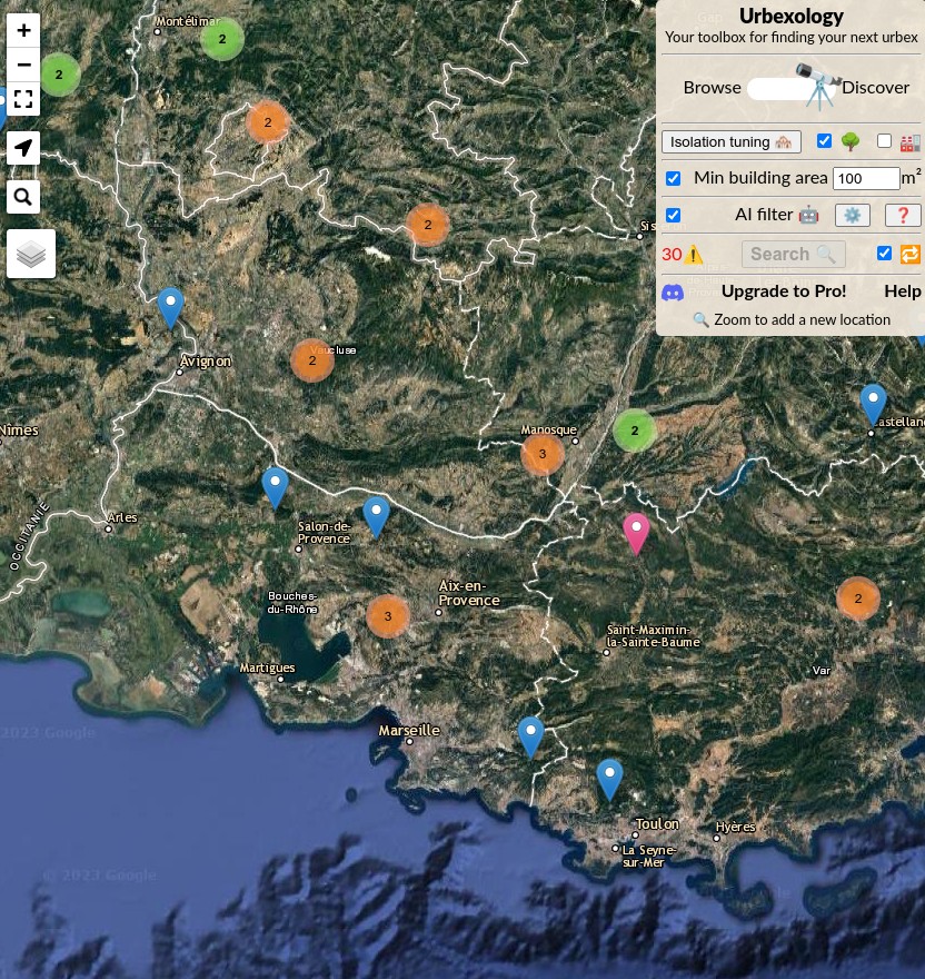
Sharing metadata
| og:url | https://urbexology.com/en.html |
|---|---|
| og:type | website |
| og:image | https://urbexology.com/imgs/embedded.jpg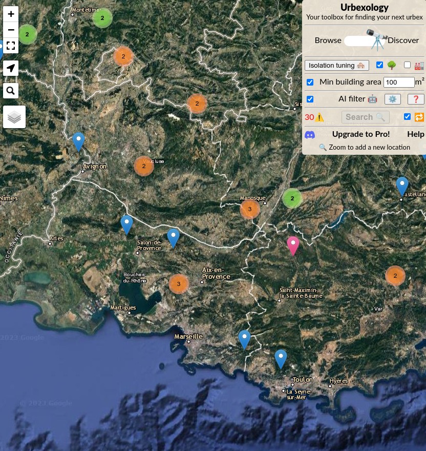 |
| og:image:type | image/jpeg |
| og:image:width | 832 |
| og:image:height | 880 |
robots.txt (opens in a new tab)
5 rulesAll bots 3 allowed · 0 disallowed

 All bots

/blog//explore//posts/
oai-searchbot 1 allowed · 0 disallowed
/
perplexitybot 1 allowed · 0 disallowed
/
No matching rules.
Sitemaps
10- https://urbexology.com/langs.xml(opens in a new tab)
- https://urbexology.com/blog/sitemap.xml(opens in a new tab)
- https://urbexology.com/geo/sitemap.xml(opens in a new tab)
- https://urbexology.com/explore/sitemap.xml(opens in a new tab)
- https://urbexology.com/explore/collections/sitemap.xml(opens in a new tab)
- https://urbexology.com/explore/collections/fr/sitemap.xml(opens in a new tab)
- https://urbexology.com/explore/collections/de/sitemap.xml(opens in a new tab)
- https://urbexology.com/explore/collections/ja/sitemap.xml(opens in a new tab)
- https://urbexology.com/explore/collections/es/sitemap.xml(opens in a new tab)
- https://urbexology.com/posts/sitemap.xml(opens in a new tab)
 Registration details RDAP / WHOIS
| Registrar | NameCheap, Inc. |
|---|---|
| Registered | 2023-03-03 |
| Expires | 2027-03-03 |
| Domain status | client transfer prohibited |
| Nameservers | jaziel.ns.cloudflare.com、suzanne.ns.cloudflare.com |
| DNSSEC | unsigned |
 DNS records
| Type | Name | Value | TTL | Priority |
|---|---|---|---|---|
| A | urbexology.com | 18.67.65.102 | 60 | — |
| A | urbexology.com | 18.67.65.26 | 60 | — |
| A | urbexology.com | 18.67.65.36 | 60 | — |
| A | urbexology.com | 18.67.65.88 | 60 | — |
| AAAA | urbexology.com | 2600:9000:2269:2800:14:681:8a00:93a1 | 29 | — |
| AAAA | urbexology.com | 2600:9000:2269:9800:14:681:8a00:93a1 | 29 | — |
| AAAA | urbexology.com | 2600:9000:2269:9c00:14:681:8a00:93a1 | 29 | — |
| AAAA | urbexology.com | 2600:9000:2269:a800:14:681:8a00:93a1 | 29 | — |
| AAAA | urbexology.com | 2600:9000:2269:b000:14:681:8a00:93a1 | 29 | — |
| AAAA | urbexology.com | 2600:9000:2269:c600:14:681:8a00:93a1 | 29 | — |
| AAAA | urbexology.com | 2600:9000:2269:d000:14:681:8a00:93a1 | 29 | — |
| AAAA | urbexology.com | 2600:9000:2269:f600:14:681:8a00:93a1 | 29 | — |
| MX | urbexology.com | mx1.improvmx.com | 300 | 10 |
| MX | urbexology.com | mx2.improvmx.com | 300 | 20 |
| NS | urbexology.com | jaziel.ns.cloudflare.com | 86400 | — |
| NS | urbexology.com | suzanne.ns.cloudflare.com | 86400 | — |
| TXT | urbexology.com | google-site-verification=ylDuXvTqMbWgGqXiSf5jboLsK4o9b7ARvDF66_y5MM4 | 300 | — |
| TXT | urbexology.com | v=spf1 include:amazonses.com include:spf.improvmx.com ~all | 300 | — |
| DMARC | _dmarc.urbexology.com | v=DMARC1; p=quarantine; rua=mailto:[email protected]; pct=100; | 300 | — |
 TLS and certificates
| Assessment | Normal configuration |
|---|---|
| Supported protocols | TLSv1.2、TLSv1.3 |
| Negotiated protocol | TLSv1.3 |
| Certificate subject | www.urbexology.com |
| Issuer | Amazon |
| Valid until | 2027-03-04T23:59 · Remaining when checked: 155 days |
| Verification details | Certificate trust: Passed · Hostname match: Passed |
 HTTP response headers
| Header | Value |
|---|---|
| content-type | text/html |
| cache-control | public, max-age=3600 |
| server | AmazonS3 |
 Identified technologies
Recent Updates
- Website images
- Screenshots
- Network details
- Website Technologies
- Pages and Search Information
- HTTP Response Information
- TLS and certificates
- DNS Information
- Domain Registration
- Website profile
- Website Description
- Website Name
- Website profile
- Website Description
- Website Name
User reviews (0)