Website profiles · Technology insights · Alternatives

suncalc.org

Online application to ascertain the sun movement with interactive map, sunrise, sunset, shadow length, solar eclipse, sun position, sun phase, sun height, sun calculator, solar eclipse, elevation, Photovoltaic system, Photovoltaic

Paid content
Visit website
Profile views 13 Outbound visits 0 Normal
SunCalc Full homepage screenshot

At a glance

Category
Resources & Utilities
Language
English
Paid-content signal
Paid contentObserved
Registered
2015
Hosting
IONOS SEInferred
HTTPS certificate trusted
PassedObserved
Last updated

Website review

This review may include AI-generated content and is not individually verified. Domain, certificate and other facts come from the observed data on this page.

What is SunCalc?

SunCalc is a free online tool for checking where the sun will be at a given place and time. You pick a location on an interactive map and a date, and it shows the sun's path across the sky along with sunrise, sunset, culmination (solar noon), dawn and dusk, day length, altitude, azimuth and shadow length. A time slider lets you scrub through the day, with colors indicating the sunlight phase, and a live mode follows the current moment until you stop it.

What you can do with it

  • Plan around light. Photographers, filmmakers and event organizers can check whether a location will be in sun or shade at a chosen hour, and how long shadows will be.
  • Judge solar exposure. The photovoltaic section covers solar constant, air mass and irradiance, useful for a rough sense of how much sun a site receives.
  • Work with coordinates. You can enter or read latitude, longitude, UTM coordinates and time zone, and run a reverse calculation from a shadow back to the sun's position.
  • Check astronomical detail. Declination, right ascension and equinox/solstice dates are listed for those who want more than the practical numbers.
  • Print or share results. Current data, a full day's data or the map can be printed, and the site offers instructions for linking to the page and for developers.

Practical example

Suppose you are scouting a park for a late-afternoon portrait session in June. Enter the park's coordinates, set the date, and move the slider to 17:00. The map shows the sun's azimuth so you know which way to face your subject, and the shadow-length figure tells you whether nearby trees or buildings will block the light. Repeat for a September date to see how much earlier the light drops.

Things to keep in mind

  • The default view is a computation for a selected location and day, not a weather forecast; clouds and local obstructions are not modeled.
  • The photovoltaic figures are solar-geometry estimates, not a substitute for a full site survey or equipment sizing.
  • The site is donation-supported via PayPal, and it points to companion tools for the moon, planets and satellites.

Next step

Open SunCalc, search for your location, set the date, and drag the time slider across the hours you care about. If you need moon phases or satellite passes, the site links to dedicated companion tools for those.

How can I use SunCalc to plan the best time for outdoor photography or gardening based on sun position?

SunCalc is a free interactive map-based tool for checking sun position, sunrise/sunset times, shadow length and sun height for any place and date. For photography or gardening, its main value is that you can scan a whole day or year quickly and see how light and shade actually fall at your spot, rather than relying on a generic almanac.

For outdoor photography

  • Golden hour and blue hour planning: Set your location and date, then move the time slider to see sun height and azimuth. Low sun height corresponds to the warm, directional light photographers usually want; the slider's colouring shows the daylight phases across the day.
  • Shadow direction and length: The tool reports shadow length for a given object height and the sun's azimuth, so you can predict where shadows will fall and whether your subject will be backlit, side-lit or in shade.
  • Composition and sun path: The yellow curve shows the sun's trajectory for the chosen day, while the broader yellow band shows how that path shifts through the year. Use it to pick a date when the sun lines up with a street, ridge or building.
  • Live mode: If you are on site, the LIVE option tracks the current position; stop it when you no longer need updates.

For gardening

  • Light exposure mapping: Check sun height and azimuth at several times of day to judge whether a bed gets full sun, partial shade or deep shade, and when neighbouring buildings or trees will cast shadows.
  • Seasonal change: Switch months to see how the sun path moves between the March equinox, June solstice, September equinox and December solstice. A spot that is sunny in June may be shaded in winter, which matters for overwintering plants and for crops that need consistent light.
  • Shadow length as a proxy: Long shadows mean low sun and weaker intensity; short shadows mean strong overhead light. This helps you decide where to place sun-loving versus shade-tolerant plants.

Practical next steps

  1. Enter latitude/longitude or use the map, set the date, and note sunrise, culmination (solar noon), sunset and daylight duration.
  2. Move the slider through the day and record shadow length and azimuth at the times that matter to you.
  3. Repeat for a few dates across the year to see the range of conditions.
  4. For photography, combine this with a weather forecast, since SunCalc shows geometry, not cloud cover.
  5. For gardening, verify with a site visit, because local obstacles not on the map can change the result.

Related tools

A useful decision rule: choose a date and time where the sun height and azimuth match your goal, then confirm on site. If two candidate times look equal in SunCalc, prefer the one with the shorter shadow for gardening and the one with lower sun height for warm, dramatic photography.

How do I interpret the shadow length and sun height data on SunCalc for placing solar panels?

Shadow length and sun height (altitude) on SunCalc tell you how low the sun sits above the horizon and, in turn, how long a shadow a given object casts. For solar panels, the practical takeaway is: the lower the sun height, the longer the shadow, and the more you need to worry about shading and tilt.

What the two numbers mean

  • Sun height (altitude): the sun's angle above the horizon in degrees. Higher values mean stronger, more direct light; low values (early morning, late afternoon, winter) mean weak, grazing light.
  • Shadow length: how far a shadow extends from an object of a given height. SunCalc reports it in metres, with a field for the object's level (height in metres), so you can set your own reference — a panel edge, a wall, a chimney, a tree.

The relationship is simple: shadow length grows as sun height falls. At a high noon sun, shadows are short; near sunrise or sunset, they stretch very long.

How to use it for panel placement

  1. Open the map, set your location, and pick a date.
  2. Use the December solstice (around 21 December in the northern hemisphere) as your worst case — that is when the sun is lowest and shadows are longest.
  3. Enter the height of whatever might shade your panels (roof ridge, parapet, tree, adjacent building) in the object-level field.
  4. Read the shadow length at the hours you care about, and check whether that shadow reaches your intended panel area.

For a rough rule, the critical window is usually mid-morning to mid-afternoon, not the extremes of the day. A panel shaded at 7 a.m. in December loses little; one shaded at noon loses a lot.

Decision criteria

  • If shadows from a fixed obstacle reach the panels during the December midday window, move the array, raise it, or trim/remove the obstacle.
  • If the site is clear at the winter solstice midday, it will be clear the rest of the year, because the sun only gets higher.
  • Tilt choice: the panel tilt that best matches your latitude is a starting point, but shading often matters more than squeezing out the last few percent of tilt optimisation.
  • Seasonal trade-off: a steeper winter tilt sheds snow and catches low sun better but reduces summer output. Use the sun-height curve across seasons to see how much you gain or lose.

A concrete scenario

Suppose a chimney rises 2 m above the roof and you plan panels just north of it (northern hemisphere). Set the object level to 2 m, pick 21 December, and step through the hours. If SunCalc shows a shadow of, say, 6 m at midday, the chimney will shade anything within roughly 6 m of it at that moment — so keep panels outside that reach, or accept a winter-only loss.

Related tools

For moon and planet positions alongside the sun, the same author runs MoonCalc and PlanetsCalc, and SunMoonTrack covers sun and moon tracking together.

Next step

Pick your actual location and the December solstice, set the object height to your tallest nearby obstruction, and note the shadow length at 10:00, 12:00 and 14:00. Those three readings usually decide whether a roof area is worth using.

What information can SunCalc provide about a solar eclipse, and how do I view it?

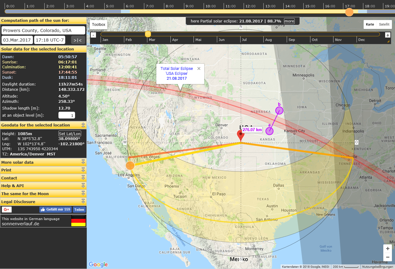
SunCalc can show whether a solar eclipse is visible from a chosen location and what the Sun's position is at that time, but it is not a dedicated eclipse-path viewer. The eclipse data appears alongside the usual solar readout for the selected place and date.

What you get for an eclipse

  • A marker or overlay for the eclipse on the day's Sun path, so you can see where the Sun sits during the event.
  • The standard solar figures for that moment: altitude, azimuth, shadow length, culmination, sunrise/sunset, daylight duration, and the Sun's declination and right ascension.
  • A time slider that lets you scrub through the day to compare the eclipse with the Sun's normal trajectory.

How to view it

  1. Set your location by entering latitude and longitude, or by clicking the map.
  2. Pick the date of the eclipse using the date and month controls.
  3. Move the time slider to the eclipse window; use the arrow keys or mouse.
  4. Read the solar data panel for altitude and azimuth at that instant, and check the Sun path for how high the Sun will be.

Practical limits SunCalc is a general Sun-position tool, so it is best for "will the Sun be up and where will it be?" rather than for precise contact times or the width of the eclipse path. For path maps and timing tables, use a specialist eclipse source such as timeanddate.com or NASA. A photographer planning a shot, for example, can use SunCalc to confirm the Sun's altitude and direction at the eclipse moment, then check a dedicated eclipse map for the exact track.

A useful next step: compare SunCalc's altitude and azimuth at the eclipse time with your horizon and any obstructions, since a low Sun behind buildings or trees can matter more than the eclipse itself.

How can I share or print the sun data from SunCalc for a specific location and date?

SunCalc is built for exactly this: you pick a location and a date, then use its print options to capture the result. The page lists three print choices — Print – Current Data, Print – Data this day, and Print – Current Map — so you can output either the numeric solar figures, the day's values, or the map view itself.

For sharing, the page also offers Instructions to link to this page, which is the intended way to send someone a specific view rather than copying numbers by hand.

A practical workflow

  1. Set the location by entering latitude/longitude or clicking the map.
  2. Choose the date using the month and time controls.
  3. Optionally scrub the time slider to the hour you care about.
  4. Print the view you need, or copy the link instructions to share the same setup.

Which print option fits

Goal Use Why
A snapshot of the current on-screen values Print – Current Data Quick record of the selected time's figures
A full day's solar timeline Print – Data this day Covers sunrise through sunset for the date
Showing someone the location and sun path visually Print – Current Map Keeps the map context, not just numbers

Reader scenario

A photographer planning a golden-hour shoot at a coastal overlook would set the coordinates, pick the date, move the slider to the target hour, then print Current Data for reference and share the link so a second shooter sees the identical view. A solar-panel installer might instead print Data this day to document the sun's path across a full working day.

Decision criterion

If the recipient needs to reproduce your view, share the link; if they need a record, print. Printing the map is the better choice when the location itself is part of the message.

For related sun, moon and planet views, the page points to MoonCalc, PlanetsCalc and OrbitTrack.

What additional tools and resources does SunCalc offer for tracking the moon, planets, and satellites?

SunCalc is primarily a sun-position tool, but its operator runs a small family of companion sites for other sky objects. From SunCalc you can jump to dedicated calculators for the moon, the planets, and satellites.

Companion tools

  • Moon: MoonCalc mirrors the SunCalc approach for the moon — position, phase and path for a chosen place and date.
  • Planets: PlanetsCalc does the same for planetary positions.
  • Satellites: OrbitTrack covers satellite positions and passes.
  • Sun and moon together: SunCalc's own help text points to SunMoonTrack for viewing sun and moon movement in one place.

How to choose

Use SunCalc itself when your question is about sunlight: sunrise, sunset, shadow length, sun height, azimuth or photovoltaic-relevant irradiance. Switch to a companion site when the object you care about is not the sun — the interface logic is similar, so there is little to relearn.

A practical example: a photographer planning a twilight shoot might check sun set times and shadow direction on SunCalc, then open MoonCalc to see whether moonlight will be strong enough for the second half of the session, and OrbitTrack if a bright satellite pass could appear in a long exposure.

The trade-off is fragmentation: you move between separate sites rather than getting one combined dashboard, and each has its own location and date settings, so re-entering coordinates is part of the workflow. Start by setting your location once on SunCalc, then open the companion site for whichever object you need next.

Related questions

More questions →
What Is a Solar Eclipse and How Can You Check When It Happens?

A solar eclipse happens when the Moon passes between the Sun and Earth and casts a shadow onto Earth's surface, blocking some or all of the Sun's light from certain locations. It is only visible where that shadow falls, so the same eclipse can be total in one place, partial in another, and not visible at all elsewhere. To find out when one happens for your location, you need eclipse timing and local visibility data — SunCalc.org is built around sun position and shadow calculations rather than eclipse catalogs, so it is useful for understanding the Sun's geometry on a given day but not as a primary eclipse timetable.

The alignment that produces an eclipse

Three bodies have to line up in a specific order:

  1. Sun — the light source.
  2. Moon — passes directly between the Sun and Earth.
  3. Earth — receives the Moon's shadow on part of its surface.

Because the Moon is much smaller than the Sun but much closer, its shadow narrows to a small spot where it reaches Earth. That spot is the path of totality (or annularity). Outside it, viewers see a partial eclipse; far outside it, nothing.

Why eclipses don't happen every month

The Moon orbits Earth roughly every 29.5 days, so it passes between Earth and the Sun about once a month — yet solar eclipses are rare. The reason is that the Moon's orbit is tilted about 5° relative to Earth's orbit around the Sun. Most months, the Moon passes slightly above or below the Sun-Earth line, so no shadow lands on Earth. An eclipse occurs only when the alignment happens near the points where the two orbital planes cross (the nodes).

The four types of solar eclipse

Type What the Moon covers What you see Key condition
Total The entire Sun Day turns to twilight; the corona becomes visible Moon's apparent size is large enough to cover the Sun completely
Annular The center of the Sun, leaving a ring A "ring of fire" around the Moon Moon is farther away and appears smaller than the Sun
Partial Only part of the Sun A bite taken out of the Sun You are outside the central shadow path
Hybrid Varies along the path Total in some places, annular in others Earth's curvature changes the Moon's apparent size along the track

The difference between total and annular comes down to distance: the Moon's orbit is elliptical, so its apparent size varies. When it is close enough, it covers the Sun fully (total); when it is farther, it leaves a bright ring (annular).

How to check timing and visibility for a location

Eclipse timing depends on where you are, so a general "start time" is not enough. You need the contact times for your coordinates — when the partial phase begins, when totality or annularity starts and ends, and when the event finishes.

A practical workflow:

  1. Get the eclipse date and general region from an eclipse catalog or astronomy source.
  2. Find your local contact times using a location-aware eclipse tool or an eclipse map that lets you click your position.
  3. Check the Sun's altitude and azimuth at those times — if the Sun is below the horizon during the eclipse, you cannot see it from that spot.
  4. Confirm weather and horizon obstructions separately; no calculation tool can predict clouds.

Where SunCalc.org fits

SunCalc.org is an online application for sun movement: sunrise, sunset, shadow length, sun position, sun phase, sun height, and sun path, plus photovoltaic data. Its page evidence lists "solar eclipse" among its keywords and shows a live computation path for the Sun with dawn, sunrise, culmination, sunset, dusk, altitude, azimuth, and shadow length for a selected location.

What that means in practice: you can use SunCalc to check where the Sun will be in the sky at a given date and time for your coordinates — altitude and azimuth — which tells you whether the Sun is above the horizon and in which direction to look. It does not, based on the available page evidence, provide eclipse contact times or a dedicated eclipse path map. So treat it as a supporting tool for Sun geometry, not as your eclipse timetable.

If you want to verify shadow behavior around an eclipse, note that shadow length depends on the Sun's altitude: the lower the Sun, the longer the shadow. During a partial eclipse the light dims but the Sun's position does not jump, so shadow direction stays consistent with the Sun's azimuth.

Safe viewing: why you need eye protection

Looking directly at the Sun — eclipsed or not — can cause permanent retinal damage, and the danger is easy to underestimate because a partially eclipsed Sun is still intensely bright and does not hurt immediately.

  • Use certified eclipse glasses or handheld solar viewers that meet the ISO 12312-2 standard. Ordinary sunglasses, even stacked, are not safe.
  • Never look at the Sun through a camera, binoculars, or telescope without a proper solar filter mounted on the front. The optics concentrate light and can destroy a filter placed at the eyepiece.
  • The only safe naked-eye moment is totality — the brief phase when the Moon fully covers the Sun's bright disk. The moment any bright part of the Sun reappears, put the filter back on.
  • Indirect methods such as pinhole projection let you watch the partial phases safely without looking up.

Quick answers

Is a solar eclipse visible everywhere at once? No. The Moon's shadow covers only a narrow track, so visibility is location-specific.

Why is a total eclipse so rare at any given place? The path of totality is narrow and Earth's surface is large; a specific city may wait centuries between total eclipses.

Can I use SunCalc.org to find eclipse times? Based on the available page evidence, it computes Sun position, sunrise/sunset, and shadow length for a location — not eclipse contact times. Use it to check Sun altitude and azimuth, and use a dedicated eclipse source for the timetable.

What Are Battle Maps in Tabletop RPGs and How Do You Make One?

A battle map is a scaled, top-down map used during tabletop RPG encounters to show where characters, monsters, and terrain sit relative to each other. You use one when positioning matters — combat, chases, traps, room-by-room exploration — and skip it for purely narrative scenes. You can make one by drawing terrain in a vector editor, placing assets, then exporting for screen, print, or a virtual tabletop. DungeonFog is one tool built for exactly this workflow.

Battle map vs. world map: what's the difference

These two map types answer different questions, and mixing them up is the most common early mistake.

Battle map World / overland map
Scale One encounter area (a room, a cave, a street) A region, kingdom, or continent
Grid Usually 1-inch or 5-foot squares Rarely gridded
Detail Tactical: cover, doors, furniture, elevation Strategic: roads, towns, terrain
Used for Combat and precise movement Travel, planning, campaign context

A battle map zooms in far enough that a single chair or pillar changes your tactics. A world map zooms out far enough that a single chair is invisible. You generally need both over a campaign, but they serve different moments at the table.

When to actually put a battle map down

Reach for a battle map when the answer to "where exactly is everyone?" changes the outcome:

  • Combat — line of sight, flanking, area-of-effect spells, and movement speed all depend on position.
  • Dungeon crawling — doors, corridors, and room shapes matter for exploration and ambushes.
  • Chases and escapes — distance and obstacles drive the tension.
  • Stealth and traps — who is standing where determines what gets triggered.

Skip the map for shopping, negotiation, travel montages, and any scene where nobody cares about exact distance. Forcing a grid onto a conversation slows the game down.

How to make a custom battle map

DungeonFog describes a three-step process: create a map, place assets, then export and play. Here's what each step involves and what to expect.

1. Draw the terrain

Start with the layout — dungeon walls, building floor plans, or overland terrain. DungeonFog uses a vector-based editor, which means shapes stay sharp when you scale or print them, rather than turning blurry like a stretched bitmap. Draw the rooms and corridors first; decoration comes later.

2. Place assets

Populate the map with props, furniture, and terrain features. DungeonFog's library lists over 3,000 assets spanning different time periods and settings, and new asset packs are released monthly as part of its premium content subscription. Search the library for the pieces that match your story rather than settling for whatever's closest.

3. Export and play

You can play with others inside DungeonFog itself, or export and print the map. Exporting is where your earlier choices pay off — a vector map holds up at print resolution, and a well-scaled grid keeps tokens aligned.

Key considerations before you commit

  • Grid scale. Decide your squares-per-inch (or per-5-feet) before you draw, not after. Changing it later means redoing the layout.
  • Resolution. If you plan to print, you need higher resolution than for on-screen play. Vector output helps here.
  • Asset library size. A bigger library means less time hunting for the right prop — but also more browsing. Check whether the library covers your campaign's setting (fantasy, modern, horror, etc.).
  • Where you'll play. On screen, printed, or inside a virtual tabletop each has different export needs.

Ways to play with your map

  • On screen — display the map on a TV or monitor laid flat or mounted, and move physical minis on top.
  • Printed — export at print resolution and tile the pages for a physical battle mat.
  • In a virtual tabletop — play with others inside DungeonFog, or export the file for use in your VTT of choice.

The practical takeaway

If you only need a quick sketch, paper and a marker still work. If you want reusable, high-detail maps that survive printing and scaling, a vector editor with a large asset library saves real time across a campaign. DungeonFog fits that second case — free to sign up, with premium memberships and a marketplace for additional content. Check the pricing page for current tiers before committing, since asset packs and premium features sit behind that subscription.

How to Use SunCalc.org to Check Sun Position, Sunrise/Sunset, and Shadow Length

SunCalc.org is a free browser-based sun calculator that shows, for any place and date, the sun's path across the sky along with sunrise, sunset, culmination, altitude, azimuth, and shadow length. You set a location on an interactive map or by entering coordinates, pick a date, and drag a time slider to watch the sun move. It works for planning photography, checking whether a spot gets shade at a given hour, sizing a solar panel setup, or just understanding how the sun behaves at your latitude across the year.

Setting Your Location

The calculator needs a place before it can compute anything. You have two ways to give it one:

  • Click the map. The interactive map centers on your chosen point, and the coordinates update automatically.
  • Enter coordinates directly. Use the Lat and Lon fields to type a latitude and longitude, then apply them with the Set Lat/Lon control.

After the location is set, confirm the time zone (TZ) and the DST setting. These matter because sunrise and sunset are reported in local clock time — if the time zone or daylight-saving flag is wrong, every time in the output shifts. The panel also shows the location's height (elevation) and a UTM coordinate, which are useful if you're matching the tool against survey or mapping data.

Picking a Date and Moving Through the Day

Use the month selector (Jan through Dec) and the date range controls to choose the day you care about. Then move through the day with the time slider:

  • Drag the sun on the slider with the mouse, or
  • Use the arrow keys on your keyboard for finer steps.

The colors on the time slider represent the sunlight phase during the day, so you can see at a glance when it's dark, when the sun is low, and when it's high. There's also a LIVE mode that tracks the sun in real time; click STOP-LIVE to end it and return to manual control.

Reading the Output

Once a location and time are set, the panel reports the day's key solar events and the sun's current position:

Output What it tells you
Dawn, Sunrise, Culmination, Sunset, Dusk The times of each phase, with culmination being the sun's highest point of the day
Daylight duration Total length of the day between sunrise and sunset
Altitude How high the sun is above the horizon, in degrees
Azimuth The sun's compass direction
Shadow length [m] The length of a shadow cast at the current sun angle
Distance [km] Distance to the sun at that moment

The shadow length figure is tied to an object height you specify (the "at an object level [m]" input). Set the height of the object — a person, a building, a pole — and the tool returns how long its shadow will be at the selected time. This is the number to check when you want to know whether a wall, tree, or neighboring building will shade a spot at 3 p.m. in June.

Understanding the Sun-Path Curve

The map draws the sun's trajectory as a thin yellow curve. Two things to read from it:

  • The curve itself is the sun's path for the selected day.
  • The yellow band around it shows how that path shifts across the whole year — the spread between the shortest and longest days.

The closer a point on the curve is to the center of the display, the higher the sun is above the horizon. So a curve that bulges far toward the center means a high summer sun; a flatter curve hugging the edge means a low winter sun. Comparing the band's edges tells you how much the sun's path changes between seasons at your latitude.

Reverse Calculation and Photovoltaic Data

Two extra features handle more specific tasks:

  • Reverse Calculation works backward from a shadow to the object or angle that produced it — useful when you've measured a shadow and want to infer the sun position or object height.
  • Photovoltaic section reports solar constant, air mass, and irradiance for the selected location and time. These are the inputs you'd want when estimating how much sunlight a panel would receive, rather than just where the sun is.

The panel also lists astronomical values such as declination, right ascension, GMST, GHA, JDE, and DeltaT, plus the dates of the equinoxes and solstices. These are reference figures for anyone doing more precise solar or astronomical work.

Printing and Saving Results

The tool offers three print options: Print – Current Data, Print – Data this day, and Print – Current Map. Use these to keep a record of a specific moment, a full day's solar table, or the map view with the sun path drawn on it.

Practical Notes

  • If times look off by an hour, recheck the DST setting first — it's the most common source of confusion.
  • The shadow length depends entirely on the object height you enter, so set that before reading the number.
  • The site also links to companion tools for the moon (mooncalc.org), planets (planetscalc.org), and satellites (orbtrack.org) if you need the same kind of position data for other objects.
  • A German-language version is available at sonnenverlauf.de.
How Shadow Length Is Calculated and How to Check It with a Sun Calculator

Shadow length is the ground distance from the base of an object to the tip of its shadow. For a vertical object on flat ground, it equals the object's height divided by the tangent of the sun's altitude angle: shadow length = height ÷ tan(altitude). The lower the sun sits in the sky, the longer the shadow. You can get this number for any place, date, and time with a sun calculator such as SunCalc.org, which reports "Shadow length [m]" alongside the sun's altitude and azimuth.

The core relationship

Two inputs determine shadow length:

  • Object height — how tall the thing casting the shadow is.
  • Sun altitude — the angle of the sun above the horizon at that moment.

The formula follows from a right triangle: the object is the vertical side, the shadow is the horizontal side, and the sun's altitude is the angle at the shadow's tip.

Sun altitude Shadow length (for a 1 m object)
90° (directly overhead) 0 m
45° 1 m
30° ~1.73 m
10° ~5.67 m
1° ~57.3 m

At very low altitudes the shadow grows without bound, which is why shadows stretch out dramatically near sunrise and sunset.

Shadow direction

Length tells you how far the shadow reaches; azimuth tells you which way it points. The shadow falls on the opposite side of the object from the sun. If the sun's azimuth is due south, the shadow points due north. SunCalc reports azimuth as part of its solar data, so you can pair it with the shadow length to place a shadow on a map or plan.

Getting shadow length from SunCalc

SunCalc.org shows the sun's movement and sunlight phases for a chosen day and place, and its solar data panel includes a Shadow length [m] field.

  1. Set the location — enter latitude and longitude, or use the map to pick a point.
  2. Set the date and time — choose the day and drag the time slider (mouse or arrow keys) to the moment you care about.
  3. Read the solar data — the panel lists dawn, sunrise, culmination, sunset, dusk, daylight duration, distance, altitude, azimuth, and shadow length.
  4. Use the object height field — the panel shows shadow length "at an object level [m]," so you supply the height and the tool returns the corresponding shadow length.
  5. Reverse the calculation if needed — a reverse calculation option lets you work backward from a known shadow to another value.

The time slider also colors the day's sunlight phases, and the yellow curve traces the sun's path, so you can see how altitude changes across the day and how that drives shadow length.

Practical uses

  • Photography — long low-angle shadows near sunrise and sunset create dramatic depth; knowing the length helps you frame a subject.
  • Solar panel siting — panels and nearby structures cast shadows that reduce output; shadow length at low sun angles shows how far shading reaches.
  • Outdoor shade planning — awnings, trees, and buildings cast predictable shadows you can size against a patio or seating area.
  • Architecture and landscaping — checking shadow reach at different seasons helps place windows, overhangs, and plantings.

Limits to keep in mind

The formula assumes flat ground and a vertical object. Real conditions change the result:

  • Sloped terrain shortens or lengthens the visible shadow.
  • A tilted object casts a shadow that no longer matches the simple height ÷ tan(altitude) rule.
  • Obstacles, buildings, and vegetation can block or merge shadows.
  • Atmospheric refraction slightly shifts the sun's apparent position near the horizon.

Treat the calculated value as the ideal-case length, then adjust for the actual site.

Website Overview

An established domain and managed infrastructure suggest continuity of operations and may support dependable delivery, although neither guarantees service quality. Several search or sharing settings need attention. Together they may make snippets, preview images or preferred URLs less consistent across platforms.

Domain and Registration

Registered in 2015, this domain has about 11 years of history. That suggests continuity, although ownership and purpose may have changed. Transfer-protection status is present, helping reduce the risk of unauthorized domain transfers. The domain uses the common .org extension, which is not an independent safety signal.

DNS and Email

Nameservers are provided by ui-dns.org, indicating managed DNS hosting. MX records point to the IONOS Mail email service. No CNAME was found; the observed records resolve directly to addresses. SPF and DMARC are configured. DKIM status is unknown. DNSSEC signatures were not detected, so this additional DNS authenticity protection is not confirmed.

TLS and Certificates

The certificate uses an RSA 2048-bit public key, offering broad client compatibility. The server supplied a complete certificate chain. No organization name is present in the certificate; the available fields are consistent with domain validation. The certificate was issued by Let's Encrypt, commonly associated with automated certificate services. The certificate's total validity is about 89 days, consistent with a short renewal cycle.

HTTP and Browser Security

X-Powered-By exposes backend information: PHP/7.2.34, PleskLin. The checked browser-security headers were not detected, leaving fewer explicit browser-side safeguards. No obvious internal addresses or debug information were found in the headers. The Server header identifies nginx without an exact version. No explicit CDN or WAF marker was found in the response headers.

Technology Stack Analysis

The public page identifies Google Analytics, nginx, PHP without precise versions, leaving fewer clues for version-specific scanning.

Search and Social Sharing

The title has 190 characters and may be truncated in search results. The meta description has 230 characters and may be shortened in search results. Open Graph is partially configured; og:type is missing. No Generator meta tag is publicly exposed. A viewport declaration is present, providing a basis for mobile layout.

Hosting and Email

DNSui-dns.org
HostingIONOS SE
EmailIONOS Mail
Approximate IP geolocation (inferred; a CDN or proxy may differ from the origin server) France flagFrance Inferred 217.160.169.134

Registration details

RDAP / WHOIS

RegistrarIONOS SE
Registered2015-01-28
Expires2027-01-28
Domain statusclient transfer prohibited
Nameserversns1020.ui-dns.org、ns1053.ui-dns.biz、ns1067.ui-dns.de、ns1124.ui-dns.com
DNSSECunsigned

DNS records

DNS

TypeNameValueTTLPriority
Awww.suncalc.org217.160.169.1343600—
AAAAwww.suncalc.org2001:8d8:9a0:8800::23:cdd13600—
MXsuncalc.orgmx00.ionos.de360010
MXsuncalc.orgmx01.ionos.de360010
NSsuncalc.orgns1020.ui-dns.org172800—
NSsuncalc.orgns1053.ui-dns.biz172800—
NSsuncalc.orgns1067.ui-dns.de172800—
NSsuncalc.orgns1124.ui-dns.com172800—
TXTsuncalc.orgv=spf1 include:_spf-eu.ionos.com ~all3600—
DMARCdmarc.ionos.dev=DMARC1; p=none;86400—

TLS and certificates

TLS / SSL

AssessmentNormal configuration
Supported protocolsTLSv1.2
Negotiated protocolTLSv1.2
Certificate subjectsuncalc.org
IssuerLet's Encrypt
Valid until2026-10-30T04:06 · Remaining when checked: 30 days
Verification detailsCertificate trust: Passed · Hostname match: Passed

HTTP response headers

HTTP

HeaderValue
content-typetext/html; charset=UTF-8
servernginx

Identified technologies

Google AnalyticsnginxPHP

Pages, Search and Sharing

Meta descriptionOnline application to ascertain the sun movement with interactive map, sunrise, sunset, shadow length, solar eclipse, sun position, sun phase, sun height, sun calculator, solar eclipse, elevation, Photovoltaic system, Photovoltaic
Canonical URLhttps://www.suncalc.org
LanguageEnglish (default)
Twitter CardNot detected
All bots 1 allowed · 0 disallowed
  • Allow/

User reviews (0)

  • No reviews yet.